
How Do Pilots Read and Interpret Aviation Weather Reports?

Weather is one of the most important factors pilots consider before and during a flight. Understanding the forecast helps pilots decide whether it is safe to fly, which route to take, what altitude to fly at, and whether they may need to change their plans along the way.
For student pilots, learning to interpret aviation weather reports is an essential part of flight training. These reports contain specialised terminology and abbreviations, but once you understand the basics, they become much easier to read.
Let’s look at the main weather reports pilots use and how they apply this information when planning a flight.
1. What are METAR and TAF reports?
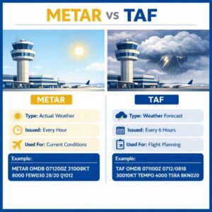
Two of the most common aviation weather reports are METAR and TAF. They provide different but complementary information.
METAR : What is the weather like now?
A METAR is a routine aviation weather report describing observed conditions at an airport. It gives pilots a snapshot of the current weather, including wind, visibility, cloud conditions, temperature and atmospheric pressure.
Pilots use METAR reports to assess conditions at their departure airport and check the latest available observations for their destination and other relevant locations.
TAF : What is the weather expected to be?
A TAF, or Terminal Aerodrome Forecast, provides a forecast of expected weather at an airport over a specified period.
It helps pilots anticipate what conditions might be like when they arrive, rather than relying only on what the weather is doing at the time of departure.
For example, the weather may be clear when a flight takes off, but the destination forecast could indicate thunderstorms developing later in the day. That information could influence the departure time, route, destination choice or decision to postpone the flight.
The key difference: A METAR tells the pilot what the weather has been observed to be, while a TAF forecasts what conditions are expected.
2. Understanding common aviation weather terminology
Aviation weather reports use standard abbreviations to communicate information efficiently. Here are some terms student pilots commonly encounter.
| Term | What it means |
| METAR | An observed report of current airport weather |
| TAF | A forecast of weather expected at an airport |
| TEMPO | Temporary fluctuations in forecast conditions during a specified period |
| INTER | In Australian aviation forecasts, indicates intermittent conditions; pilots should interpret it according to the applicable forecast format |
| FM | From — indicates the time from which a new set of forecast conditions is expected |
| BECMG | Becoming — indicates a gradual change to forecast conditions |
| PROB | Probability — indicates the forecast probability of specified conditions where this format is used |
| TS | Thunderstorm |
| RA | Rain |
| FEW / SCT / BKN / OVC | Cloud coverage categories, ranging from few clouds through scattered and broken cloud to overcast |
| KT | Knots, a unit of wind speed |
The precise interpretation of forecast groups can vary with the applicable national reporting format. Pilots learn to read these terms alongside the forecast’s validity times and the local aviation weather guidance.
Why do TEMPO and INTER matter?
These terms can be particularly important when weather conditions are changeable.
A forecast might indicate generally acceptable conditions but include a TEMPO group warning of temporary thunderstorms, reduced visibility or lower cloud during part of the forecast period.
INTER can indicate intermittent conditions in Australian forecasts. These conditions may not persist continuously, but they still need to be considered when assessing the flight.
Pilots should not assume that a temporary or intermittent weather event can simply be ignored. Its likely timing, severity and effect on the planned flight all matter.
3. Planning the weather from departure to destination
One of the most important principles of flight planning is that pilots must consider the weather for the entire journey, not just the departure and arrival airports.
A flight might begin in clear skies but encounter deteriorating conditions along the route. Weather systems can develop, move or intensify while the aircraft is airborne.
Before departure, pilots assess several factors.
Departure conditions: Is the weather suitable for take-off? Are visibility, cloud base and wind within the applicable limits for the flight and the pilot’s qualifications?
En-route conditions: What weather is expected along the route? Are there areas of thunderstorms, turbulence, low cloud, poor visibility or other hazards?
Destination conditions: Will the weather be suitable when the aircraft is expected to arrive? A destination that is suitable at departure time may not remain suitable later.
Alternative airports: If the destination becomes unsuitable, are there practical alternative airports where the aircraft can safely land?
Timing: Could departing earlier or later reduce exposure to adverse weather, provided the revised plan remains safe and operationally suitable?
This assessment allows pilots to make informed decisions before committing to a flight.
4. Choosing the right altitude and flight level
Weather information also helps pilots determine the most suitable altitude for a flight.
Winds can vary considerably with height. At one altitude, a pilot might encounter a headwind that slows progress over the ground; at another, a more favourable wind may provide a useful tailwind.
Pilots therefore consider forecast winds at different altitudes when planning a route. Choosing an appropriate altitude can improve ground speed, help manage fuel consumption and sometimes provide a smoother ride.
However, wind is only one consideration. Pilots must also account for cloud, turbulence, icing where relevant, aircraft performance, terrain clearance, airspace restrictions and applicable altitude rules.
For example, a higher altitude may offer a favourable tailwind but put the aircraft into cloud or an area of turbulence. A lower altitude might provide more comfortable conditions but less favourable winds.
The best choice is the altitude that provides an acceptable combination of safety, weather, aircraft performance and operational efficiency.
The terminology also matters. In aviation, altitude and flight level are not always interchangeable: flight levels refer to pressure-based levels used under specified procedures. The appropriate terminology and settings depend on the aircraft, airspace and operating rules.
5. What happens when thunderstorms are forecast?
Thunderstorms are among the weather hazards that require particularly careful consideration. They can produce severe turbulence, lightning, hail, strong updrafts and downdrafts, heavy rain and wind shear.
Pilots use forecasts, weather charts, radar information and other available reports to identify potential thunderstorm activity before departure.
If significant thunderstorms are expected along the route, the pilot may need to consider delaying the flight, changing the route, selecting a suitable alternative destination or not departing.
If conditions deteriorate while airborne, the pilot may need to divert to another airport or make another appropriate change to the flight plan.
A diversion is not necessarily a sign that something has gone wrong. It is a normal part of sound operational decision-making when conditions no longer support the original plan.
Thunderstorms must be avoided, not flown through. Pilots do not rely on finding a gap in a storm or on the aircraft’s ability to withstand severe weather. Decisions must be made with appropriate margins and in accordance with the aircraft’s capabilities and applicable procedures.
6. How is weather radar used during a flight?
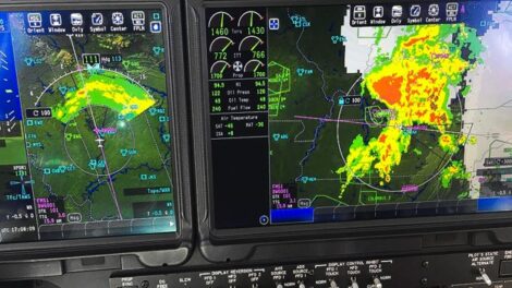
Weather radar is an important tool for identifying areas of precipitation and helping pilots assess where weather systems are located.
Depending on the aircraft and equipment available, pilots may use onboard weather radar, ground-based radar information or weather data displayed through an approved aviation system.
During a flight, radar information can help pilots identify areas of heavy precipitation, observe the position of weather cells and assess how weather is developing in relation to their route.
This information may help them determine whether a route change or diversion is appropriate.
However, weather radar has limitations. It does not provide a complete picture of every hazard, and the absence of a radar return does not guarantee that an area is safe. Radar imagery can also have limitations associated with coverage, data age and the equipment being used.
Pilots therefore combine radar information with forecasts, observations, other weather reports and their own operational procedures. They also coordinate with air traffic control when appropriate.
Radar is a tool for making better decisions, not a guarantee that a route through or around hazardous weather will be safe.
7. Weather interpretation is an ongoing process
Weather planning does not finish when the aircraft leaves the ground. Pilots continue to assess available weather information during the flight and compare what they encounter with what was forecast.
If conditions differ from expectations, they may need to reassess the route, altitude, estimated arrival time or suitability of the destination.
This is particularly important on longer flights, where weather can change significantly between departure and arrival.
Good pilots develop the habit of thinking ahead: What weather lies ahead? Is it changing? Do I have a safe alternative if conditions deteriorate?
These questions are central to sound decision-making in aviation.
Frequently asked questions
- What is the difference between METAR and TAF?
METAR reports observed weather at an airport, while TAF forecasts expected weather there over a specified period. Pilots use both to understand current and anticipated conditions.
- What does TEMPO mean in an aviation weather forecast?
TEMPO identifies temporary fluctuations in forecast weather during a specified period. Depending on the forecast, these may involve changes in wind, visibility, cloud or significant weather such as thunderstorms.
- Why do pilots check weather along the route?
Weather at the departure and destination airports does not tell the whole story. Conditions between the two locations can affect safety, comfort, fuel planning, altitude selection and whether a diversion may be necessary.
- Can pilots use weather radar to avoid thunderstorms?
Yes, radar information can help pilots identify precipitation and assess the location of storm cells. However, radar has limitations and must be used alongside other weather information and sound operational judgement. Thunderstorms must be avoided using appropriate procedures.
- Can weather affect a pilot’s choice of altitude?
Yes. Wind direction and speed, cloud, turbulence, terrain, aircraft performance and airspace restrictions all influence altitude selection. Pilots aim to choose an appropriate altitude that meets safety and operational requirements.
- Interested in becoming a pilot?
Weather interpretation is just one of the skills developed during professional pilot training. Students learn to interpret aviation reports, plan flights, assess changing conditions and make sound decisions to manage risks.
At Moorabbin Aviation Services, flight training develops the practical skills and aviation knowledge required to progress towards a commercial pilot licence.
Want to learn more about becoming a pilot? Explore our aviation training courses or contact our team to discuss your options.